Overcoming the Challenges of Busy Urban Surveying with Mobile Mapping Solutions
When surveying in city centres it often feels like cars, buses, delivery trucks and pedestrians are conspiring against project completion! Road closures and approved traffic management scenarios are becoming more time-consuming in application and costly in deployment. We were recently commissioned to provide a city centre topographical, buried utility and GPR survey in Leeds, deploying the latest survey technology to mitigate this project risk.
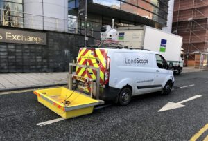
Augmenting the Trimble SX10 combined total station and laser scanner (survey control, GCP’s and detail), LandScope surveyed live carriageway, pedestrian footways and other inaccessible areas with our Leica Pegasus:Two Ultimate mobile mapping system. The resultant point cloud data set – constrained to better than +/- 10mm 3D – provided ubiquitous topographical and adjacent building model input.
Additionally, the trajectory from the Leica Pegasus: Two Ultimate was utilised to accurately position our Mobile Ground Penetrating Radar array from 3D-Radar. The mobile GPR system provided an ultra-high-resolution record of the subsurface environment and was used as input to the PAS128:2014 buried utility survey and the geophysical mapping of historic foundation and structures at the development site.
Our mobile survey solutions tick many boxes for city-centre projects including:
- exceptional high positional accuracy and high-resolution data
- integrated above and below ground in one survey campaign
- time and cost savings
- removes personnel from high-risk environments
- less intrusive to the public
- less risk of equipment theft and damage
- removes the need for costly site revisits – fewer missing data
If you would like more information on any of our survey solutions, please contact our commercial team on 01694 731930 or enquiries@land-scope.com.