MOBILE GROUND
PENETRATING RADAR
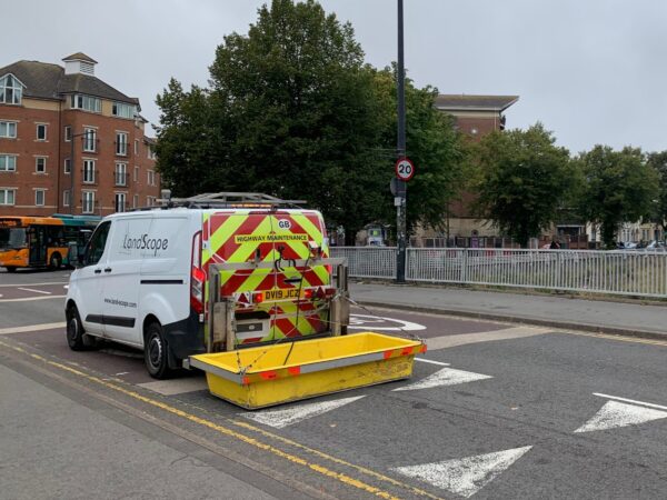
We have developed a selection of Mobile Ground Penetrating Radar (GPR) solutions to allow for rapid, efficient, and ultra-high-resolution data acquisition over large areas and in live traffic environments. For mobile GPR surveys, a multi-antenna GPR array is deployed (step frequency or dual polarised) to a Chapter 8 compliant survey vehicle, capable of covering a large swath in each pass. Data can be acquired at highway speed reducing, and in some cases removing, the requirement for traffic management. Mobile GPR surveys minimise project costs, the time required on-site and the risk of personnel working in live carriageways.
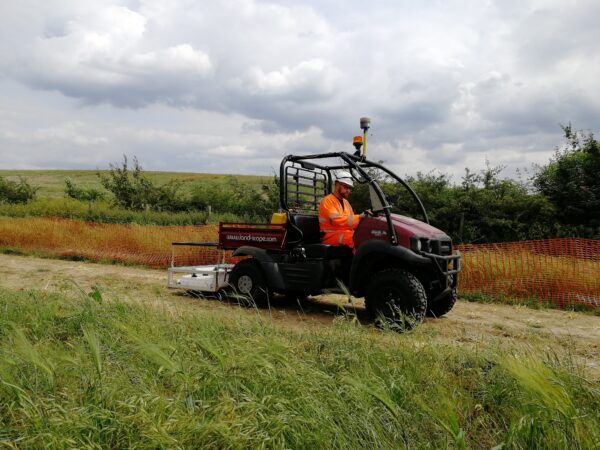
Mobile systems are easily reconfigurable into hand push systems or configured on ATV’s to allow infill of smaller or pedestrianised areas.
Our mobile GPR systems have been developed by our in-house team of geophysicists and highways surveyors, in association with equipment manufacturers Kontur (formerly 3D-Radar) and IDS, delivering rapid deployment, flexible configuration, and the highest available data quality.
Our mobile GPR systems can be deployed for a wide range of applications to include, utility mapping, pavement analysis, archaeology, void detection, structural survey, bedrock detection and many more.


BENEFITS OF MOBILE GPR SURVEYS
- Reduced Cost
- Exceptionally High Resolution
- Rapid: travelling at highway speed, mobile GPR surveys can capture up to 50 linear km of high-resolution, high-accuracy sub-surface image data per day
- No Disruption: reduces, and in some cases removes, the need for traffic management or lane closures minimising project cost and disruption
- Boots off the Carriageway: reduces health and safety risk to survey personnel
- Gap Free Coverage: overlapping swaths augmented with traditional hand-push GPR for a comprehensive survey coverage
- Optimum Data Quality: multi-frequency solution to optimise depth resolution and penetration
- Net Zero: substantial reduction in Scope 3 value chain greenhouse gas emissions
- PAS2080: carbon reduction through much greater efficiency
DEPLOYMENT OPTIONS
Highways Survey Vehicle: our custom-built Chapter 8 Highways Survey Vehicle (HSV) is configured for the deployment of our Kontur (formerly 3D-Radar) DXG-Series antenna array. To facilitate safe and effective highways working, the system can be controlled from within the cab whilst the vehicle is in motion.
Rough Terrain: just like our Highways Survey Vehicle, our rough terrain solution is a modular design that can incorporate either our systems from Kontur (formerly 3D-Radar) or Utsi Electronics allowing for a bespoke array configuration to suit site conditions and target requirements.

APPLICATIONS
- Highways Survey: pavement construction analysis, material condition analysis (voiding, moisture, delamination/debonding)
- Airport Runway Survey: condition assessment
- Buried Utility Mapping: PAS128:2022 survey, route proving, reconnaissance survey
- Site Investigation and Archaeology: underground infrastructure mapping, depth to bedrock assessment
- Rail Survey: ballast condition survey, services mapping
ACCURATE POSITIONING
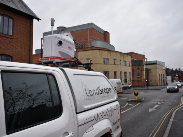
For accurate data positioning, our mobile GPR solution is integrated with either a mobile mapping system or a dedicated GNSS aided IMU. The survey benefits from the highest order of trajectory in all environments, exceeding the accuracies set out in PAS128:2022.
Added Value: the photographic and LiDAR data sets captured by the mobile mapping system can be utilised for a number of purposes including topographical feature extraction, visualisation and asset management. We can supply the mobile mapping data in several formats including via U-GIS, our cloud-based underground GIS platform.
We have developed a cloud-based data delivery platform U-GIS, to provide our customers with an easy way to view, measure and model their above and below ground survey data in one place. Get the most out of your 3D mapping data with U-GIS. Cick to find out more.