MOBILE GEOPHYSICS
As LandScope has developed, its requirement to survey large infrastructure projects has grown. To offer cost effective and efficient surveys, LandScope have mobilised a range of geophysical sensors.
Often multiple sensors are combined to enhance performance further and ensure data collected at speed over large areas is every bit as accurate and to the same resolution as traditional collection methods.

MGPR
Our Mobile GPR system utilises a step frequency Kontur Antenna. Its wide frequency bandwidth makes it ideal for a wide range of applications such as, utility mapping, pavement survey, archaeology, moisture content etc.
The vehicle mounted system mitigates much of the need for traffic management and LandScope have also developed several off road (ATV) mounted systems to cover all terrain.
For accurate data positioning, our mobile GPR solution is integrated with either a mobile mapping system or a dedicated GNSS aided IMU. The survey benefits from the highest order of trajectory in all environments, exceeding the accuracies set out in PAS128:2022.
Added value: the photographic and lidar data sets captured by the mobile mapping system can be utilised for a number of purposes including topographical feature extraction, visualisation and asset management. We can supply the mobile mapping data in several formats including via U-GIS, our cloud-based underground GIS platform.
UAV MAGNETOMETERS
LandScope have developed its in-house UAV capabilities to include UAV based magnetometry. This system allows rapid data collection all year round and can mitigates issues such as terrain, vegetation, crops and water.
The UAV mag system can be set to fly at a range of heights depending on target size and sensitivity. Not all sites or applications are suitable for UAV based deployment (sometimes there is no substitute for the traditional) but LandScope will recommend the most effective collection system for each individual project.
MAGNETOMETER ARRAYS
Traditionally most magnetometer surveys were completed by two hand-carried sensors. Landscope utilise multi sensor array (5+ sensors) mounted on a hand or vehicle towed cart. These systems can offer higher resolution by reducing sensor interval or are capable of covering large areas of land rapidly.
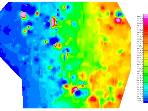
VEHICLE MOUNTED GROUND CONDUCTIVITY
Ground Conductivity has a huge range of applications and is one of the most flexible geophysical techniques. The sensors are capable of simultaneously detecting ground conductivity and magnetic susceptibility that further increase its functionality. Similar to GPR, the sensors range in antenna size and spacing. This can be tailored to the specific target of interest. Smaller sensors/spacing offer higher resolution whilst larger sensors/spacing offer an increased depth penetration.
Applications cover both environmental and engineering requirements. These can include cavities (including mines and sink holes), former landfill sites (+ leachate plumes), geological features, buried structures / foundation, metallic objects and buried services. Ground conductivity sensors are generally mounted from a QUAD, ATV or towed platform.
VEHICLE MOUNTED TIME DOMAIN ELECTROMAGNETICS (TDEM)
The primary advantage of time domain electromagnetics is the ability to map both ferrous and no ferrous metal objects. Data is recorded at multiple time gates to improve target characteristics.
LandScope can deploy multiple EM61 systems via the GEEP or EM63 Flex platform.
HYDROGRAPHIC GEOPHYSICS
With application of the latest technologies and acquisition systems, LandScope is well positioned to support marine engineering projects with the highest quality geophysical surveying services. Geophysical sensors will be selected based on individual project and client requirements and can be readily installed and interfaced to any of our dedicated survey vessels.
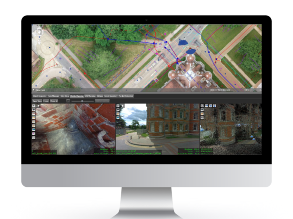
BENEFITS OF U-GIS
- Added Value: get the most out of your existing 3D mapping data. Large volumes of data are captured within the field, and it is becoming increasingly difficult to display this wealth of data within traditional survey packages. This digital approach provides significant added value.
- Cost Savings: a single centralised database that is accessible to all project stakeholders minimises the risk of duplicating tasks. All stakeholders have access to the most up to date site data.
- Collaboration: housing all data within a single environment encourages collaboration and data sharing across departments. The additional intelligence can help to make informed decisions and avoid downstream variations.
- Point and Click: the easy-to-use cloud-based interface means users simply click on an asset to access a wide array of metadata, photography, and legacy information.


