
Point Cloud Survey: From Site Data to CAD
Point Cloud Survey: What Can the Data Tell You?
A point cloud survey creates a detailed digital record of a site. However, it provides much more than an impressive 3D image. Each point contains accurate spatial information that can be measured, analysed and used by project teams.
LandScope Engineering captures this information using mobile mapping and laser scanning. As a result, engineers and designers can explore existing site conditions without making repeated visits.
What Can Be Identified?
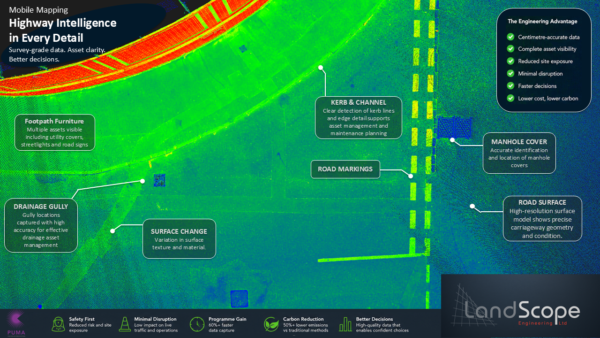
A point cloud can capture a wide range of visible features, including:
- Buildings and structures
- Roads, kerbs and footways
- Road markings
- Street furniture
- Lighting and traffic signals
- Drainage features
- Utility access covers
- Barriers and boundaries
- Vegetation
- Surface levels and gradients
These features can then be measured and extracted to meet the needs of each project.
Point Cloud Survey: From Site Data to CAD
From Point Cloud to CAD
LandScope can transform the captured data into practical project deliverables. These can include:
- 2D topographical surveys
- 3D CAD models
- Cross-sections and elevations
- Digital Terrain Models
- BIM-ready models
- GIS datasets
- Asset schedules
Importantly, the original data remains available after the first deliverables have been produced. Therefore, additional details can often be extracted later if the design or project scope changes.
Better Data for Better Decisions
A point cloud survey gives the whole project team access to one accurate source of information. This improves design confidence and helps different disciplines work together.
It can also reduce repeat site visits, shorten survey programmes and lower project risk. In addition, teams can review complex locations remotely before making design or construction decisions.
Supporting Infrastructure Projects
LandScope delivers point cloud data for highways, utility routes, structures, industrial sites and other complex environments.
Do you need accurate survey data for your next project? Contact LandScope Engineering to discuss how a point cloud survey could support your planning, design or asset management requirements.